Skip the Highway; Build a Boulevard
Re-envisioning multi-million dollar Bayfront Parkway Project

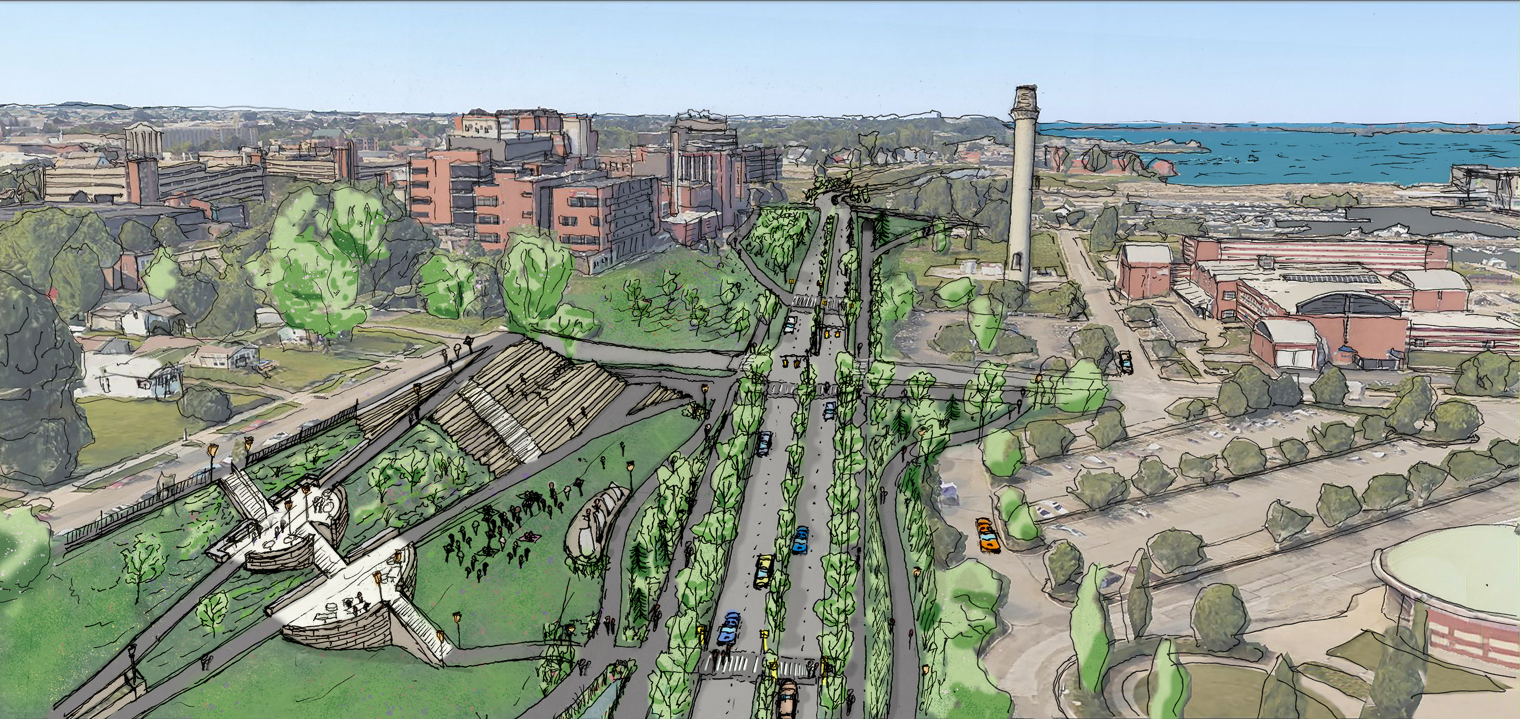
This artist rendering by Maxwell J. Hentosh illustrates CIVITAS and Connect Urban Erie's vision of a Bayfront Boulevard complete street and Bluffside Park near the Holland intersection. This concept represents a pedestrian-friendly alternative to PENNDOT's planned Bayfront Parkway project, which would reinforce the Bayfront's current use as a high-speed vehicular traffic corridor, severing the waterfront from downtown.
In 2018, preliminary engineering began for the Bayfront Parkway Project, with construction slated to begin in late 2021. PennDOT's plan, estimated to cost between $70 and $100 million, features an underpass at State Street, "highway-style exits," and multi-lane roundabouts in support of the 80 percent of Bayfront drivers currently bypassing the city and cutting off the downtown from the waterfront.
When spending this much taxpayer money, the review process must be completed to understand how the project will impact the community. Thus, the PennDOT project was scheduled for an Environmental Assessment (EA), the normal review to determine possible harm to residents, and the environment. However, in March, PennDOT applied for a lesser review — a Categorical Exclusion (CE). CEs are normally granted for small projects like bridge repair or roadway repaving. PennDOT claimed that their massive project has no environmental impact or substantial controversy. Neither is true.
In response to concerns including a letter from the Erie Bayfront Coalition, City Council tabled a July 1 Resolution granting permission to begin PennDOT's project. Letters from PennFuture and Congress for the New Urbanism urged both an EA and Environmental Impact Statement. On July 15, Council removed the resolution from the agenda and scheduled a study session.
A highway will diminish the existing downtown-to-waterfront connections (and complicate future ones.) PennDOT's plan ignores a key principle of the *Erie Refocused and *Active Transportation plans: prioritize the needs and preferences of people walking and biking.
If the highway is built, residents will face twice the traffic, and at least twice the roadway width at crossings. To attempt to remedy the harm they'll be exacerbating, PennDOT has proposed huge, enclosed pedestrian bridges. However, bridges are unlikely to be built without private funding – a solution that may restrict access.
Roundabouts are dangerous, especially for residents who are physically or visually impaired. In July, a distracted driver braked sharply to avoid hitting a Fairview pedestrian in the Millfair roundabout. Soon after, a second car ran into the back of the first. A roundabout at the bottom of Holland Street's steep hill will be dangerous.
In the highway-loop around Erie (from I-79 to the Bayfront, to the Rt.290/Connector to I-90), the 4.5-mile Bayfront is the only gap in PennDOT's high-speed, 4-lane route. If Bayfront traffic doubles, PennDOT says the Eastside's Rt.290/Connector traffic will reach 24,000 a day. Today (post-Viaduct) the bike path along the busy, Rt.290/Connector arterial highway is the only route for many eastside residents, including schoolchildren.
As thriving cities around the world are transforming highways into boulevards or parks, why is Erie building a highway? Too many local leaders are still embracing a dated, automobile-centric belief that development requires Upper Peach Street style highway access and vast parking lots, where it is impossible to walk.
Erie Refocused lead author Charles Buki said "it is hard to imagine . . . a more squandered asset in America than the City of Erie's shoreline." Buki called for an "iconic connection" – not a highway severing downtown from the water. Former Destination Erie project manager Michael Furhman explained the Bayfront's problem is not traffic congestion, but how to get "the most out of our amazing waterfront." Fuhrman warned that PennDOT's plan "may give us traffic efficiency" but will stop people from moving "easily between the Bayfront and downtown." He believes PennDOT's plan will discourage new residents, the people "desperately needed for revitalization."
Currently an obstacle, Erie's 40-foot-high bluff is an underutilized asset. A Bluffpark could connect the downtown to the waterfront with paths (and tiered seating) giving people a wonderful view of Presque Isle Bay. Paths would create new connection points throughout Erie's West and East Bayfront neighborhoods, spreading economic enrichment along the bluff, the city, and region.
Consider that 20 years ago, Milwaukee Mayor John Norquist's demolition of the Park East highway was controversial. Yet, this Great Lake city's subsequent Renaissance proved that connecting assets helped Milwaukee flourish. The Milwaukee Independent recently reported the $25 million in federal funds used to tear down the highway and provide "tax-increment financing to cleanup … and re-establish a street grid" created "a magnet for corporate headquarters" (including Erie's own Zurn Industries) resulted in "$2 billion of economic impact."
In 2015, Norquist visited Erie as a guest of Preservation Erie. Learning of PennDOT's plans, Norquist commented "Erie will be all alone in building a waterfront highway." Norquist says PennDOT's plan "will reduce the attractiveness and value of Erie substantially and probably permanently."
When is Erie going to stop repeating the mistakes of the past?
Urban highways are history. Let's move the traffic cutting through the city to a streamlined 12th Street – and build a human-scaled Bayfront Boulevard serving all of Erie's residents.
You can help protect the Bayfront by calling for an Environmental Assessment. Learn more at ConnectUrbanErie.com.
Lisa Austin and Adam Trott are members of CIVITAS and Connect Urban Erie.


